Identity area
Reference code
Title
Date(s)
Level of description
Extent and medium
19pp
Context area
Repository
Archival history
Immediate source of acquisition or transfer
Content and structure area
Scope and content
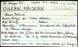
Set of index cards describing the local features of the townland of Oileán Máisean [Mason Island]. Included in the descriptions are Mulán na Srathrach/An tSrathair [Straddle Rock on the OS maps], Bealach na Srathrach, Trá an Éadain, Trá Bheirtreach, Carraigh Dháimhiú, Tóin an Oileáin, Guaire na gCrámha, Aill na Croise, Garbhcharraig (Rough Rock on the OS maps), Carraig an Ghun (Gun Rock), Oileán Aimhréidh (Avery Island), Garraí na Cilleach (marked as a burial ground on the OS maps), Lochán an tSeanduine, Carraig an tSnámha, Loch na dTaibhsí, An tAircín, Béal an Tairsí, and Oileán an Chortha. Some local individuals are credited with providing some of the information given for this townland, namely Joe Casey, an O Cathasaigh (noted as Joe Casey's son), and Brian Skinner.
Appraisal, destruction and scheduling
Breisiúcháin
System of arrangement
Conditions of access and use area
Conditions governing access
Open
Coinníollacha a rialaíonn atáirgeadh
Teanga an ábhair
Script of material
Nótaí teanga agus scripte
Physical characteristics and technical requirements
Áiseanna aimsithe
Allied materials area
Existence and location of originals
Existence and location of copies
Related units of description
Note
[Table]
Catalog
Alternative identifier(s)
Access points
Subject access points
Place access points
Name access points
Genre access points
Description identifier
Institution identifier
Rules and/or conventions used
Status
Level of detail
Dátaí cruthaithe athbhreithnithe nó scrios
05/08/2014
02/06/2015