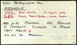
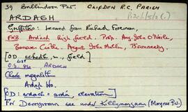
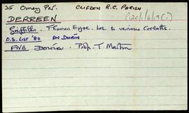
Set of index cards describing some of the local features of the townland of Derreen. Included are descriptions of a Megalithic Tomb and nearby ringfort. A small doodle is also included. A note on the card indicates Tim visited this in 1989.
Robinson,TimMegalithic monuments
17 Archival description results for Megalithic monuments
Set of index cards describing some of the local features of the townland of Couravoughil [Corr an Bhachaill]. Included are descriptions of Wood's Field, Simon's Falls, a Megalithic Tomb, and Clifden Glen. Rory Lavelle is credited with providing some of the local information.
Robinson,Tim,Lavelle,RorySet of index cards describing some of the local features of the townland of Ballynew [An Baile Nua]. Descriptions are given of a 'pair of standing stones', Fuaigh an Sconsa (Ooeyasconsa on the OS maps, and known locally as Fo na Sconsaí), Fó na Bróinge (Tim Robinson believes the cove may be named for its boot-like shape), Fó na Labhráis (Ooeylaunlauraush on the OS maps), Fó na Bhistí, Fuaigh an Duine Mhairbe (Ooeywaria on the OS maps), Binn Ghlais, Fó an Uisce, Fó an Bhradáin, Megalithic tombs close to the Children's Burial Ground, Lios (the site of the former Mission School), and the Shrine, which marks the traditional site of St. Ceannan's beheading. J O'Toole of Moyard, Mr. Heanue of Bundouglas, and Con Mullen of Ballynew are credited with providing some of the information.
Robinson,Tim,O'Toole,J.,Mullen,ConSet of index cards describing some of the local features of the townland of Aughrus More, [Eachros Mór]. Included is a brief description of a megalithic structure.
Robinson,TimSet of index cards describing some of the local features of the townland of Ardkyle, [Ardchoill]. Descriptions are given of Freaghillaun South (Freegh Island), Carraig Ghéar (Carrigeen South), Cuainin Garbh, Ross Beach, Poll na gColm (Ooeycolum on the OS maps), Glasoileán, Leac na mBó, Leac na Sronna, and Fruaigh Leathan. Some notes are included offering musings on the meanings of the different place names. Paddy Heanue of Letterbeg, and an old man who lives in the last cottage in Ardkyle are credited as providing some of the information therein. A note on a ruined megalith, 25 metres from a cliff ledge. A letter from Mike Gibbons (1988), is credited as being the source of some of the information.
Robinson,Tim,Heanue,Paddy,Gibbons,MikeSet of index cards describing some of the local features of the townland of Ardagh, [Ardach]. Included are descriptions of a megalithic tomb, earthworks, rock carvings, Derrywaking Lough, Mass Rock, the estate of P J Kendall, Ardagh House and Lodge, Ardagh Oyster Fishery, and Loch na Fiacaile. Paul Mohr who discovered the rock carvings, Professor Noel Wilkins' book, and the Connery brothers of Becaunín are all credited with providing information.
Robinson,Tim,Mohr,Paul,Wilkins,Noel