Megalithic monuments
17 Archival description results for Megalithic monuments
Set of index cards describing some of the local features of the townland of Glencraff, [Gleann Creamha]. Included are descriptions of Aill an Ghabhair, Gabhlóg Struthán Mór, Clochán na Bean Sí, Sruthán Mór, Anacair, Children's Burial Ground, Lug na Coille, Eas Dubh, Doirín, Lug an Fhia, Ceannáin Bhán, Cloch an Domhnaigh, Búcán, Cnocán an Iolra, Aill an Iolra, The Glen River, Pulófra, Megalithic Tombs, the Holy Well (which is locally associated with a St. Craff), Cloichín, and Easca Riabhach. Michael O'Néill and Chris O'Néill are credited with providing the information.
UntitledSet of index cards describing some of the local features of the townland of Tooreen, [An Tuairín]. Included are descriptions of Giant's Grave, an unclassified megalithic tomb, and the Old Clifden to Ballynakill road. Local man Mr. Lydon is credited with providing some of the information.
UntitledSet of index cards describing some of the local features of the townland of Tooreena, [Tuairín Áithe]. Included are descriptions of Greenmount House, an unclassified megalithic tomb, the Giant's Grave, Marconi Station, Talamh Garbh River, Tulach Gaoithe, and Lín an Tuis. Mike Gibbons and Philip Coyne are credited with providing some of the local information.
Untitled
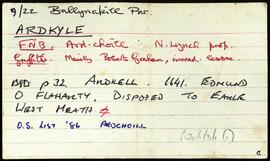
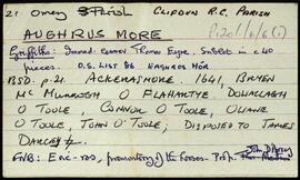
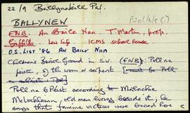
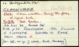
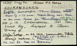
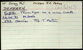
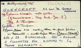
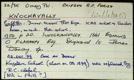
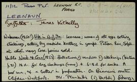
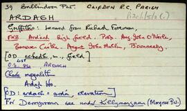
Set of index cards describing some of the local features of the townland of Ardagh, [Ardach]. Included are descriptions of a megalithic tomb, earthworks, rock carvings, Derrywaking Lough, Mass Rock, the estate of P J Kendall, Ardagh House and Lodge, Ardagh Oyster Fishery, and Loch na Fiacaile. Paul Mohr who discovered the rock carvings, Professor Noel Wilkins' book, and the Connery brothers of Becaunín are all credited with providing information.
UntitledSet of index cards describing some of the local features of the townland of Aughrus More, [Eachros Mór]. Included is a brief description of a megalithic structure.
UntitledSet of index cards describing some of the local features of the townland of Couravoughil [Corr an Bhachaill]. Included are descriptions of Wood's Field, Simon's Falls, a Megalithic Tomb, and Clifden Glen. Rory Lavelle is credited with providing some of the local information.
UntitledSet of index cards describing some of the local features of the townland of Derreen. Included are descriptions of a Megalithic Tomb and nearby ringfort. A small doodle is also included. A note on the card indicates Tim visited this in 1989.
UntitledSet of index cards giving a description of the townland of Knockavally, [Cnoc an Bhealaigh]. Included are a rough sketch of Knockavalley wedge (dated 26 July '06), The Three Stones (a megalith, includes a small sketch), and Kingstown Church.
UntitledTwo index cards giving a brief description of the townland of Letternoosh, [Leitir Núis]. Included are a brief description of a megalith, and a small illustration. Mike Gibbons is noted as describing the megalith as a wedge tomb.
Untitled