


Identity area
Reference code
UGA P/P120/1/10
Title
Kilcummin Civil Parish [Paróiste an Chnoic and Paróiste an Spidéal Roman Catholic Parishes]
Date(s)
Level of description
Sub-series
Extent and medium
322 pp
Context area
Repository
Archival history
Immediate source of acquisition or transfer
Content and structure area
Scope and content
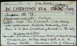
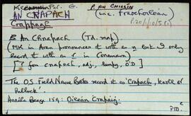
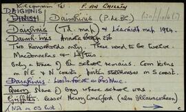
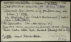
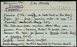
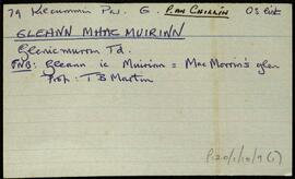
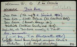
Set of index cards describing the local features of townlands in the civil parish of Kilcummin. The Roman Catholic parishes of Paróiste an Chnoic and Paróiste an Spidéal are represented, and a note on the Barony of Moycullen, as well as overall population numbers from 19th century census.
The majority of these townlands contain a brief 1-2 cards for each placename, and contain less of the anecdotal/descriptive content of the other civil parishes. The information conveyed here is generally a line from the OS Field Name Books Small Names Index, and a line or two from Griffith's Valuation.
Appraisal, destruction and scheduling
Breisiúcháin
System of arrangement
Conditions of access and use area
Conditions governing access
Open
Coinníollacha a rialaíonn atáirgeadh
Teanga an ábhair
Script of material
Nótaí teanga agus scripte
Physical characteristics and technical requirements
Áiseanna aimsithe
Allied materials area
Existence and location of originals
Drawer 6
Existence and location of copies
Related units of description
Note
[Table]
Catalog
Alternative identifier(s)
Access points
Subject access points
Place access points
Name access points
Genre access points
Description identifier
Institution identifier
Rules and/or conventions used
Status
Catalogued
Level of detail
Dátaí cruthaithe athbhreithnithe nó scrios
28/10/2014
10/03/2017