Ireland : Townland)

Elements area

Taxonomy

Code

Scope note(s)

    Source note(s)

      Display note(s)

        Hierarchical terms

        Ireland : Townland)

          Equivalent terms

          Ireland : Townland)

            Associated terms

            Ireland : Townland)

              217 Archival description results for Ireland : Townland)

              217 results directly related Exclude narrower terms
              Glebe
              UGA P/P120/1/10/79/1 · Item
              Part of Personal

              Index card relating to the townland of Glebe, [An Ghléib].

              Robinson,Tim
              Glen
              UGA P/P120/1/6/31/1 · Item
              Part of Personal

              Set of index cards giving a description of the townland of Glen, [An Gleann]. Included are descriptions of rock shelters (possibly Booley huts), Loch na h-uamain (the lake of the cave), Farawan Lake (the local pronunciation, Lough Nawarawaun on the OS maps), and Meall agus Caorán. Mike Gibbons, and Philomena and Tom Welsh of Cushatower are credited with providing some of the local information.

              Robinson,Tim,Gibbons,Mike,Welsh,Philomena,Tom
              Gleninagh
              UGA P/P120/1/3/33/1 · Item
              Part of Personal

              Index card describing some of the local features of the townland of Gleninagh, [Gleann Eidhneach]. See also Roundstone Parish for descriptions of local feautres. One card is included here, giving references to more information about the townland.

              Robinson,Tim
              Glinsce
              UGA P/P120/1/2/23/1 · Item
              Part of Personal

              Set of index cards describing some of the natural physical features of the townland of Glinsce [Glinsk]. Various sources are referenced giving insights into the origin of the placename, from Patrick Weston Joyce's 'The Origin and History of Irish Names of Places, Vol 3', which interprets it as the glen of the bramble bushes, to a local man who believes it derrives from 'gleann uisce'. Some notes are also provided on the modern day uses of buildings referenced in the OS maps, for instance the local school, Glinsk House, and Marble Studio. The physical features described are Loch an Roisín, Rusheen Point, Cnoc Glinsce, An Charraig Leith, Caladh Beag, An Caladh Mór, Corrán, a Children's Burial Ground, Loch Bhairtle, Barr an Linnín, Cnoc Bharr an Linnín, Abhainn Bharr an Linnín, Loch Cnocán na gCalapp, Caladh Thiobóid, Loch na Dubhaí (Lough Peastia on the OS maps, from the Irish word for worm, péist), Loichín Bharr an Chriathrach, Barr an Chlaí, Loch an Chaoráin, Céibh an Chaltha Mháire, Loch an Tamhnaigh, Tamhnachaí, Loch na Liathróide, Tulach na mBan, Loch an Mheill Mhóir, Tobar Mhuire, and Cuan na Beirtrí Buí. Information sourced from Bedford's map, Annála Beaga, and locally from Seán Ó'Ceoinín, Josie McDonncha, Frank Keaney and his grandmother, Josie Phádraig Cionnaigh, and Tomás Ó'Conghaile.

              Robinson,Tim,Ó'Ceoinín,Seán,McDonncha,Josie,Keaney,Frank,Cionnaigh,Josie Phádraig,Ó'Conghaile,Tomás
              Glionnán / Gleannán
              UGA P/P120/1/2/24/1 · Item
              Part of Personal

              Set of index cards describing some of the natural physical features of the townland of Glionnán/Gleannán [Glennaun]. Anecdotal information from the Annála Beaga, and reference to Ferdinando Follin [Feargananim Folan], the landowner in 1641, later disposed to Sir Thomas Meredith. By the time of the sale of the Martin Estate in 1849, the land was used by tenants for putting cattle out to pasture. Features described include Tamhnach na gCoileach, Cnocán an Bhodaigh, Loch Fhada Ghlionnáin [Glennaun Lodge on the OS maps], and Aill Mhór Ghlionnáin. Some of the information Tim Robinson found for Glennán was in a letter by Eoin Ó'Néill. Seán Ó'Ceoinín is also a local source of information.

              Robinson,Tim,Ó'Ceoinín,Seán,Ó'Néill,Eoin
              Gorteennaglogh
              UGA P/P120/1/3/34/1 · Item
              Part of Personal

              Set of index cards describing some of the local features of the townland of Gorteennaglogh, [Goirtín na gCloch]. Included are the story behind the song 'Amhráin Chlainne Gael', and descriptions of St. Patrick's National School, Tully Cross Chapel, , Gorteennaglogh enclosure, Gorteen Bay and Quay, Tully Cross, Ceartaí, and The Rape Hill, which is thought to refer to a rape field that was there in the time of the Blakes.

              Robinson,Tim
              Gortmore
              UGA P/P120/1/10/42/1 · Item
              Part of Personal

              Set of index cards relating to the townland of Gortmore [An Gort Mór].

              Robinson,Tim
              Gortnegragh
              UGA P/P120/1/11/56/1 · Item
              Part of Personal

              Index card for the townland of Gortnegragh/Gortnagroach [Gort na gCruach].

              Robinson,Tim
              Gorumna
              UGA P/P120/1/11/16/1 · Item
              Part of Personal

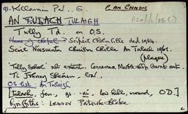
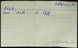
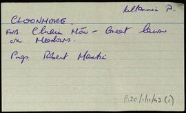
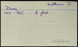
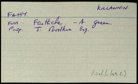
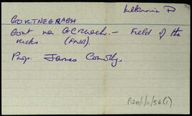
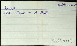
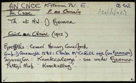
              A set of index cards describing some of the local features and the history of the island of Gorumna, [Garmna]. A note about efforts by Roger Casement to ease the plight of the islanders, 50 of whom had died of typhus.

              Robinson,Tim
              Gowlaun
              UGA P/P120/1/10/77/1 · Item
              Part of Personal

              Index card relating to the townland of Gowlaun, [An Gabhlán].

              Robinson,Tim