Identity area
Reference code
UGA P/P120/1/6/35
Title
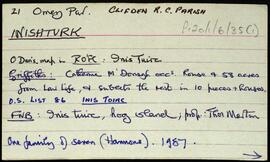
Inishturk
Date(s)
Level of description
Item
Extent and medium
16pp
Context area
Repository
Archival history
Immediate source of acquisition or transfer
Content and structure area
Scope and content
Set of index cards giving a description of the townland of Inishturk, [Inis Toirc]. Included are descriptions of Black Stick (a hill), Cara Chnoic, Baile Thoir, Baile Thios, Cuainín, Reilg, Caibidie, An tOileán Íseal, Glasoileán, Caladh Mór, Cnoc na Móna, Maoilín, Fuach Mhór, Carraig Mhuiris, and Tóin Rua. Mr. Hannon or Inishturk, and Mr. McDonagh of Eyrephort are credited with providing some of the local information.
Appraisal, destruction and scheduling
Breisiúcháin
System of arrangement
Conditions of access and use area
Conditions governing access
Open
Coinníollacha a rialaíonn atáirgeadh
Teanga an ábhair
Script of material
Nótaí teanga agus scripte
Physical characteristics and technical requirements
Áiseanna aimsithe
Allied materials area
Existence and location of originals
Existence and location of copies
Related units of description
Note
[Table]
Catalog
Alternative identifier(s)
Access points
Subject access points
Place access points
Name access points
Genre access points
Description identifier
Institution identifier
Rules and/or conventions used
Status
Catalogued
Level of detail
Dátaí cruthaithe athbhreithnithe nó scrios
07/10/2014
16/07/2025