Identity area
Reference code
Title
Date(s)
Level of description
Extent and medium
78pp
Context area
Repository
Archival history
Immediate source of acquisition or transfer
Content and structure area
Scope and content
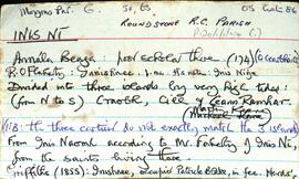
Set of index cards describing the physical features of Inis Ní [Inishnee]. Located in Moyrus Civil Paris, and the Roman Catholic Parish of Roundstone. Robinson explains that Inis Ní is divided into three islands by very high tides. From North to South, these are Craobh, Cill, and An Ceann Ramhar. Data from the 1820, 1841, and 1851 census returns are included, Congested Districts Board data, some history of ownership dating back to the 16th century, and some information from the 1st Report of the Fishery Commissioners in 1836. Physical features which are described are: Tobar Cholm Cille [on the OS map, St Brendan's Monument is marked in the same place], Árd na gCapall, Caladh na bPortán, Caladh Flathartaigh, An Sruthar, Cloch Mhór Róisín, Poll Pháidí, Caladh Keane, Tuairín, Cora Mhór, Scaith Dhubh, Caorán, Glasoileán, Gleann na gCoileach, Carraig an Bhranda, Oileán an Chlaí, Loch Bheag, Gleann na gCat, Cnocán Mhairgín, An Storraicín [An Stoiricín], Aille an Gharraí Rua, Aille na Caillí, Cara Beag(a), Doilín Freangach, Caladh Cam, Cuan Leice, Poll Tobac, St. Mathias's Chapel, Na Bruachaí [Mud Hole], Maoilín Dóite, Cáblachaí, Caladh na Loinge, St. Brendan's Well, Inis Ní Lighthouse, Gleann na gCapall, Troscaí, Cnocán Árd Dhaibhéis, Oileán an Choirce, Aill na nÉan, Dóilín Mhór, Bóthrín Gaskin, An Chloch Bhiorrach, Croabh [Creevecarton], An Ceann Ramhar, Cill, Aill Dingle, An Duirling Bhán, Crompán Mór, Oileán na gCapall, Caladh Bháid Mhóir, Gleann Dúlamáin, Cnocán an Tuairín, An Comhartha, Cnocán Tine Cnáimh, Giúróg, Mhaidin an tSagairt, Cora Mháire Ní Iarla, Doire Fhatharta, Donegal, Carraig an Fox (connected with the story of the fox and the limpet - see also Fox Island, near Cashel), Cnocán an Fhatharta, Coirnéal Sáraithe, Cooneen na Roan, Cuainín, the Inis Ní Bridge, The Wire, Fort Island, Inis Ní National School, Muing na Fola, Daoláin, Tobar an Rí, and The Danes Fort. Many local sources are credited with providing information and stories. Those credited are Pádraig Nee, Festy Nee, Rose Green, Michael King, Mr Faherty, Martin Keene, Michael Keane, Conor Hamill, Paddy Folan, and Nimmo's map of 1823.
Appraisal, destruction and scheduling
Breisiúcháin
System of arrangement
Conditions of access and use area
Conditions governing access
Open
Coinníollacha a rialaíonn atáirgeadh
Teanga an ábhair
Script of material
Nótaí teanga agus scripte
Physical characteristics and technical requirements
Áiseanna aimsithe
Allied materials area
Existence and location of originals
Existence and location of copies
Related units of description
P120/3/3/9/2/6 for photographs
Note
[Table]
Catalog
Alternative identifier(s)
Access points
Subject access points
Place access points
Name access points
Genre access points
Description identifier
Institution identifier
Rules and/or conventions used
Status
Level of detail
Dátaí cruthaithe athbhreithnithe nó scrios
08/07/2014
10/09/2023