Identity area
Reference code
Title
Date(s)
Level of description
Extent and medium
66pp
Context area
Repository
Archival history
Immediate source of acquisition or transfer
Content and structure area
Scope and content
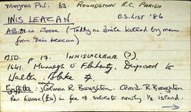
Set of index cards describing the local features of the townland of Inis Leacan [Inishlackan]. The ownership of the island is outlined from the 17th century, tracing its custodianship from the O'Flaherty clan, to the Blakes, the Broughton family from 1835, and Robert Macready of Ballinafad who bought it in 1900. Other sources of information consulted during this are listed as the 1st Report of the Fishery Commissioners, which came out in 1836, and Alex and John's log books, as well as a book entitled 'Three Men on an Island'. Some information on the Broughton family sourced in Griffith's Valuation is the subject of a couple of index cards. The features of Inis Leacan described here include Bodkin's House, some information about an account given by D'arcy Wentworth Thompson of a stay in Roundstone. Inis Leacan's school is also described, which closed in 1925 when the numbers fell below 25 pupils. The Mountain View Lodge, former home of the Broughton family, now a ruin is also described. Other physical features of the area that are described, are the Caorán, Duirling Mhór, The North Side of the island (as distinct from Trá Valley), Trá Valley (sometimes referred to as Trá an Bhaile), Carraig an Ghabhair, Fuaigh na Móna, Garraí Láir, Garraí Mór, Cnocán Mór, the Lighthouse Garden, Cnocán an tSagairt, Maoileann Garbh, Poll na Bantraí, Poll Bhairtleimíd, Poirín Beag, Poll na Cloiche, Trá na Feamainne, Cor na Cloiche, Raic Bay, Tóin an Oileáin, Trá Bheag, Aill na Brón, Poll na Stiúrach, Trá Roilligh, Barr na Leapa, Searrach Beag, Searrach Mór, Inis Leacan harbour, Poll Bréan, Inis Leacan beach, Cnocán an Ghréasaí, Cora Lín, Fuaigh Chaol, Carraig an Duilisc, Table Rock, Duirling na Glafaí, Carraig Íochtair, Céibh Mhaitiú, Carraig Báid Bán, Cloch Bhuí, Sceird, Lochán na mBallach, Garraí na Scraithe, Carraig na Ceilpe, Carraig an Iasc, Carraig na Leabhaí, Carraig na bPortán, Leachta Buí, Aill an Chipín, Carraig na gCon, Carraig na Beirtrí, and St. MacDara's well. Paddy McDonagh is a local source credited with providing information.
Appraisal, destruction and scheduling
Breisiúcháin
System of arrangement
Conditions of access and use area
Conditions governing access
Open
Coinníollacha a rialaíonn atáirgeadh
Teanga an ábhair
Script of material
Nótaí teanga agus scripte
Physical characteristics and technical requirements
Áiseanna aimsithe
Allied materials area
Existence and location of originals
Existence and location of copies
Related units of description
P120/3/3/9/2/6 photographs
Note
Catalog
Alternative identifier(s)
Access points
Subject access points
Place access points
Name access points
Genre access points
Description identifier
Institution identifier
Rules and/or conventions used
Status
Level of detail
Dátaí cruthaithe athbhreithnithe nó scrios
23/06/2014
10/09/2023