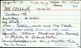
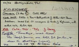
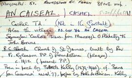
Set of index cards describing historical and physical features of Cashel [An Caiseal], as well as anecdotes about some of the local businesses. A note on the first card notes that Cashel is not part of the Gaeltacht area in Connemara. Descriptions are included of the Roman Catholic Church of St. James, the Zetland Hotel, Cashel House, Muing na Fola, Aill na gCapall, O'Loghlen's Pier, Mass Rock, Loch Gleann Cromáin, Loch Tan, Caiseal Árd, Cnoc na Mantróg, Cashel Fort, Tobar Chonaill, Glaise Feadha, Cnoc an Chaisil, and Meall an tSaighdiúra. Various literary and personal sources are credited with providing information. Those named include Willie O'Malley of Ballinafad and M. Canavan. Robinson has added information in as he discovered it, with multiple cards about Cashel House, the Zetland, and St. James' church spread out.
UntitledSet of index cards describing the physical features of Iorras Beag Thoir [Errisbeg East]. Located in Moyrus Civil Parish, and the Roman Catholic Parish of Roundstone. The features described include Aill na cGuinneog, Scailp an Tobac, Loch Beag, The Long Hollow, Leachta Tom, Daniel O'Connell's stone (a boulder from which he addressed a meeting), Mícheál's Grave (story behind this is included), the local school, the wire, Béal an Shéarain, Gleann Dárois, Loch Beanna Dubha, Aill an Eibhinn, Tower an Phuca, The Dog Lake, Cúgla [Coogla/Cúige Veadh], Mass Rock, Church, Loch Róisín na Róige, French Heath Tamnóg, Goibín Géar, Errisbeag House, Adhfola, Doire Chonna, Cloch an Dorais, Caorán Elder, Ballintan, The Tower, Bolard, The Malt House, The Fairy Woman's House, and Cnoc an gCorrbhéal. Some local people are credited with providing information. These are named as John King, Tommy O'Donnell, Mrs de Courcy, Festy Keane, Paddy Conroy, Michael Conneely,
UntitledSet of index cards describing some of the features of the townland of An Coillín [Cuilleen]. Included in the descriptions are Mass Rock, Tóin Naigín, Caladh Mhacaí, Gleann an Tobair, a cave sometimes known as Poll an Phíobaire, An Choraínn, Abhainn an Mhuilinn, Abhainn an Choillín, Lough Corker, Gleann an tSéideáin, Loch na Tulaí Buí, An Píosa Réidh, Loch an Amoileáin, Carraig Eanoinn, Aill a Gharrett, Poll an Mhianaigh, Cuan an Choillín, An Coréal, Roisín an tSamha, Loch an Gharraí, Scailp Mhór, An Sean-gharraí, Poll an Chiste, Garraí Thaidhg Mhór, Loch Mhaoilre, and Cnoc an Choillín. E O'Neill, Sgt. P O'Conghaile/Conaola, and Bríd Bean Uí Chonaola credited with providing some of the information.
UntitledSet of index cards describing some of the local features of the townland of Kylemore, [An Choill Mhóir]. Included are descriptions of Kylemore House Hotel (including references to various historical sources, and a brief outline of its ownership since it was constructed in 1785), Kylemore Fishery, Gleann Carbaid, Kylemore Woods, Binn Bhreac, Kylemore Lough, Holy Well, Benfree, Mám na Gaoithe, Mám na Scailpe, Kylemore National School, Gort an Roisín, Clochar, Taobh Bán, Mass Rock, Kylemore Pass Hotel, and the Roman Catholic Chapel. Professor Noel P Wilkins, Noel Kirby, and Leo McDonald are credited with providing some of the local information.
Untitled