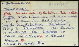
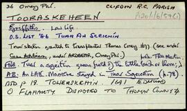
Showing 43308 results

Archival description
708 results with digital objects Show results with digital objects
UGA P/P164/4/5 · Container · 03/11/2001-10/12/2001
Part of Personal

CD-RW (written August 2003) containing:
-172 aerial photographs of the Tuam and Headford areas of County Galway (3 November 2001 – 6 December 2001);
-262 aerial photographs of sites in County Sligo taken as part of a study in advancement of the realignment of the N17 road (10 December 2001);
-Materials compiled for an archaeological survey of a proposed development site in Carrowmoneash and Frenchfort, Oranmore, including 31 site photographs and Casey's final report (23 November 2001 – 8 December 2001).

2002 – Malmo Winter 2001-2
UGA P/P164/4/6 · Container · 02/01/2002
Part of Personal

CD-RW containing personal family photographs taken by Markus Casey during a trip to Malmö, Sweden.

UGA P/P164/4/7 · Container · 15/08/2001-28/02/2002
Part of Personal

CD-RW (copied August 2003) containing:
-Materials compiled for an archaeological survey of a proposed development site in Carrowmoneash and Frenchfort, Oranmore, including photographs and Casey's final report (15 August 2001 – 8 December 2001, 34 files);
-167 photographs of confirmed and/or potentially significant archaeological and historical sites in the Tuam and Headford areas of County Galway (3 November 2001 – 28 January 2002);
-2 aerial photographs of an undisclosed rural coastal residential area (16 January 2002).

N5 – Longford Bypass
UGA P/P164/4/8 · Container · 15/10/2001-06/02/2002
Part of Personal

CD-RW (written 30 May 2002) containing 70 aerial photographs taken during an aerial survey of the proposed corridor for the N5 road around Longford.

UGA P/P164/4/9 · Container · 09/08/2001-29/07/2003
Part of Personal

CD-RW (copied October 2004) containing:
-Materials pertaining to a site inspection performed by Markus Casey at a site adjacent to Kilsaran Concrete's quarry at Bunaterin, just west of the village of Mucklagh near Tullamore. Casey found no clear evidence of archaeological sites that would be disturbed by the expansion of the quarry. Includes Casey's site report (January 2002, 7pp; for physical copy see P164/1/1/12), plus correspondence, an invoice, and 30 aerial photographs of the site (9 August 2001 – 29 July 2003);
-Report (.doc format) written by Markus Casey for Tom O'Keeffe. Casey was commissioned to inspect a site in Lydacan, Claregalway O'Keeffe wished to build upon. The site formerly incorporated a late medieval tower house (Lydacan House) that was largely demolished in 1992 by a previous landowner, and had been annotated as early as 1778 as the site of a ruined castle, which the current landowner was unaware of and created a delay in the development of the site. Casey recommends a programme of mitigatory measures to mitigate any possible interference with medieval remains that the proposed development might incur (September 2001, 15pp; see P164/3/8/1 for related materials);
-Archaeological assessment (.doc format) written by Markus Casey of No. 20, Long Walk, Galway, which deemed the site to be archaeologically resolved (20 March 2002, 3pp).

UGA P/P164/4/10 · Container · 08/05/2002
Part of Personal

CD-RW containing documents and drawings pertaining to the realignment of the N5 road at Longford and construction of the M11 motorway near Enniscorthy.

UGA P/P164/4/12 · Container · 14/01/2002-20/06/2002
Part of Personal

CD-RW containing:
-59 aerial photographs taken during an April 2002 survey of central Ireland (9 April 2002);
-30 aerial photographs surveying Belturbet, Enniscrone, Tobercurry, Killala, and Carrowkeel (16 April 2002 – 26 April 2002);
-10 photographs of an archaeological dig at Brackloon Castle (7 May 2002);
-15 photographs taken during a boat tour off County Cork (4 May 2002 – 6 May 2002);
-48 aerial photographs taken during June 2002 (6 June 2002);
-8 photographs from a field survey at Westport 20 June 2002);
-36 personal photographs taken during a flight emanating from Lough Erne, County Fermanagh (17 August 2002);
-42 photographs of historic sites at Ballaghaderreen, County Roscommon (19 November 2002).

UGA P/P164/4/13 · Container · 03/07/2002-26/07/2002
Part of Personal

CD-RW containing 204 aerial photographs and 30 ground-level photographs of areas within proposed corridors for realignment of the N4 road through County Westmeath. All photographs are from July 2002 despite the title of the CD-RW.