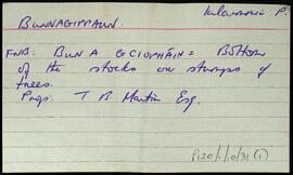
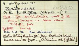
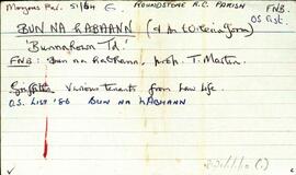
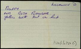
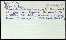
Set of index cards describing some of the local features of Bunnakill [Bun an Choill]. Included are brief descriptions of Bofin Lodge (a derelict 2-storey house known locally as Lyons's), and a note from the small names index about Tullan tanvaun.
Robinson,TimIndex
655 Archival description results for Index
Two index cards relating to the townland of Bunnagippaun, [Bun na gCeapán].
Robinson,TimSet of index cards describing some of the local features of the townland of Bundouglas [Bun Dúghlaise], located at the mouth of the Black Stream, Douglas. Some notes from the auction of the Martin Estate in 1849, pointing out a possible contradiction with Griffith's Valuation. Fó na Slanntraí, and a note of a grave marked on the OS maps, but of which Tim Robinson can find no trace, are described. Local man Mr. Heanue is credited with providing some of the information.
Robinson,TimSet of index cards describing the physical features, many of which are small islands, of Bun na hAbhann, [Bunnahown]. Descriptions are given of Oileán na gCaorach, Cora Sheáinín Mainnín (a northern point on the inlet), Tobar Muire, na Cairrgí Dubha, Barr na dTamhnach, Loch an Phoill Mhór, Corn Island, Loch an Tairbh Dhuibh, Oileán Aodha, Oileán Chamaill, Glasoileán Mór, Oileán Donn/Domhain, Oileán Gorm, Caladh Cam, Cruachnait (Croghnut on the OS maps), Rua-oileán, Leacht na bhfaoileán, and The Wire (a long natural causeway of rocks). Tim Robinson cites local sources as having helped wtih much of the information gathering, with particular mention of M. Clogherty, Anthony Ridge of Bun na hAbhann, Máirtín Ó'Catháin of Gabhla, Patrick King's son, and MacDara Green.
Robinson,Tim,Clogherty,M.,Ridge,Anthony,Ó'Catháin,Máirtín,Green,MacDaraA set of index cards outlining some of the local features of the townland of Breenaun, [Na Braonáin]. Summary notes outlining the origin of the placename (a small fairy mount according to the OS Field Name Books), its proprietor at the time of Griffiths Valuation, and descriptions of a mass grave of famine victims, Log an Ime, a ruined Abbey, 3 steep mountains, and Breenaun Bridge. A detailed note on Sruthán an Leachta, local lore on the origin of the name 'Braonán', some illustrations of different headstones in the graveyard, and Leacan.
Robinson,TimList of local features for the townland of Brannock Island [Oileán Dá Bhrannóg], part of the Civil Parish of Árainn, Inishmore. Cló Droimín, Carraig Jácom, Poll an Bhráca, An Aircín, An tUlán Buí, An Scailp, Carraigeachaí Báite, An Dul, An Trá Bhig, An tOileán Iarthach, Scailpt na mBallach Mór, Carraig Fhada, An Bodach Crom, An Clochar Bán, Leic na Creathnaí, An tOileán Thiar, An tOileán Thoir, An Breachlainn, Carraig Éamonn Rua, Oileán an dá Bhranóg/Bhruithneog, Leacrachaí Buí, Cloch Phádraic Póil, Carraig Chiúin, Cloch Scoilte, An Caladh, Leic Uí Scannláin, Poll Gorm, Carraig Dhubháin, and Carraig Eamonn mhac Donnacha.
Robinson,TimIndex card describing some of the local features of the townland of Bovroughaun, [Both Bhrocháin]. Loch Aill Mhaintáin is included in some of the descriptions of the area.
Robinson,TimSet of index cards describing physical features in Both Íseal, [Boheeshal]. A note to say the townland is not a Gaeltacht speaking area. Included are information about Loch Coirill, Cloch Coirill, and Criathrach Coirill. One card deals with translations of the townland name. Also mentioned are Loch Pholl an Mhaide Giúse, Cloch Leathbhealaigh, and the Figure Eight (two lochs joined by a few yards of stream). Several hillocks are also described, Tulach Pheadair, Tulach Poirín, Tulach Glas, Liagan Mór/Beag, and Tulach Srutháinín. There is also a Loch Tulach Srutháinín, which appears as Loughaunemlagh on the OS maps. Loch an Fhraoigh, which appears as Lough Duff on the OS maps. Finally Clogher, and Loch an Clogher. Sources of information for Both Íseal were P. Joyce and his son Úraid, and Mr. O'Malley.
Robinson,Tim,Joyce,P.,ÚraidSet of index cards describing some of the local features of the townland of Boolard, [An Bhuaile Ard]. Included are descriptions of The Priory (the big house on the south of the road opposite Boolard Island, sometimes known as The Bishop's House), The Bishop's Rock, Copper Mine (marked as shaft on the OS), Boolard Island, and a note on Reverend Anthony Magee who was a significant land owner in the area in the 19th century. Patrick Joyce of Coolacloy is credited with providing some of the local information.
Robinson,Tim,Joyce,Patrick