
Index
655 Archival description results for Index
655 results directly related
Exclude narrower terms

UGA P/P120/1/10/33/1
·
Item
Part of Personal
An index card relating to the townland of Carrowndulla, [Ceathrú an Dola].
Robinson,Tim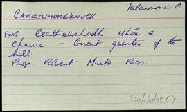
UGA P/P120/1/10/35/1
·
Item
Part of Personal
Aset of index cards describing some of the local features of the townland of Carrowmoreknock, [Ceathrú Mhór an Chnoic].
Robinson,Tim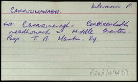
UGA P/P120/1/10/34/1
·
Item
Part of Personal
Two index cards relating to the townland of Carrowmanagh, [An Cheathrú Mheánach].
Robinson,Tim
UGA P/P120/1/2/9/1
·
Item
Part of Personal
Set of index cards describing some of the features of the townland of Carna. Description of Annála Beaga, a pub built by a priest, which later sold fishing gear. Included in the descriptions are the RIC Barracks (a fellow of the ruined barracks in Caherciveen), Cúbh an Chrompáin, Poll an Athar Peadar, Teach Phobail Naomh Maire, Idir Dhá Locha, An Sruthán Dearg, Ruaoileán, An Chréibhín, Cora Bharr na hAbhann, Loch na Lannach, Abhainn Bheag, Abhainn na Seainimhe, Loch na Calgaí, Lathach na bhFód, Na Dolachta Móra agus Beaga, Oileán an Fhiaich, Oileán na Scuaibe, Na Searaí, Baile an tSléibhe, An Tulach, Abhainn Charna, Caorán Chárna, Roisín na Tamhnaí, Dothulach, Cluais Ghiorria, and Loch Céim na Caillí. Seán Ó'Ceoinín, a Bourke of An Troscán, J Guairim, Roisín Ní Mainiach, and John Mercer credited with providing some of the information.
Robinson,Tim,Ó'Ceoinín,S.,Guairim,J.,Ní Maithniach,Roisín,Mercer,John
UGA P/P120/1/10/37/1
·
Item
Part of Personal
An index card relating to the townland of Cappanalaurabaun, [Ceapach na Lára Báine].
Robinson,Tim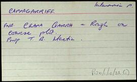
UGA P/P120/1/10/32/1
·
Item
Part of Personal
An index card relating to the townland of Cappagarriff, [An Cheapach Gharbh].
Robinson,Tim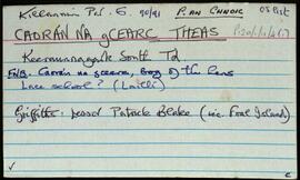
UGA P/P120/1/11/4/1
·
Item
Part of Personal
Set of index cards detailing some of the local features of the townland of Caorán na gCearc Theas, [Keeraunnagark South]. Included are descriptions of Cuan Dubhóige, Loch an Sticín, Lochán an Chalgach, An Cudú, Cannon Rock, Oileán an Bhronaigh, Aill an Bhréagaire, Toit Chonáin (an 8 foot mound of periwinkle shells), Céibh an Chaoráin, Oileán Ainnise, Poll Aill an Arbhair, and Loch an tSeanbhaile. Seán Ó'Fhatharta is credited as being a local source of information.
Robinson,Tim,Ó'Fhatharta,Seán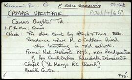
UGA P/P120/1/7/6/1
·
Item
Part of Personal
Set of index cards describing some of the local features of Camas Uachtair, [Camus Oughter]. Included are descriptions of Foirnís (in the area where the chapel is now. The furnace burned timber from Leitir Mór na Coile, and was the site of a local iron ore industry in the mid 18th century. Also included are descriptions of Cnoc Chamais (Camus Hill), An Tamhnach, Loch an Níocháin, the local chapel, Oileán na Scailpe, Príosún Chamais, Lín an Ghoirt Runna (sometimes referred to locally as Poll an Ghoirt Runna), Loch an Fhealltóra, Loch na Foirníse, An Chora Fhada, Cora na Móna, Poll an Phíobaire, Stór Chamais (which was burned by the Black and Tans in 1921), An Snáimhín, Loch na Lannach, Cnocán na gCloch, Cora an Fhealltóra, Bóthar na Trinse, Cnocán an Tobac, Béal Chamais, Cuan Chamuis, Garmain Chaoráin Aodh, Cora na mBád, Boithrín Bháibín, An Chora Bháin, Seana Bháird, Na Corannaí, Cnoc na Sciortán, Crompáin Láibe, An Claí Nua, and Céibh na mBád. Fr. Leo Ó'Morchán of Rosmuc, Pater Flaherty of Camas, and a reference to 'Órán na nIontas' are credited as being sources of some of the local information.
Robinson,Tim,Ó'Morchán,Leo,Pater Flaherty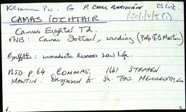
UGA P/P120/1/7/5/1
·
Item
Part of Personal
Set of index cards describing some of the local features of Camas Íochtair, [Camus Eighter]. Included are descriptions of An Seanséipéal, Loch an Iolra, Loch an Chriathraigh, An Baile Thiar, Cora Cláir, Céibh an tSagairt (a large stone pier 400 yards south of the bridge), Camas Craoibhe, Aill na bPáistí, Luifearnán, Cuan Chamais, Poll Chamais, Caorán an Iolra, Loch Chamais, Áth na gCorp, Bóthar an Cheap, Corr na Raithní, Cora Phatch Bhairtle, Caladh Domhain, Aill na gCaorach, Leacht na Sapeirs, Aill Mhór, Carraig an Bhaile, and Béal an Dá Linnín. A local person identified as Welby, Peter Flaherty of Camas, and Paddy Folan of Scríb are credited as being local sources of information.
Robinson,Tim,Flaherty,Peter,Folan,Paddy