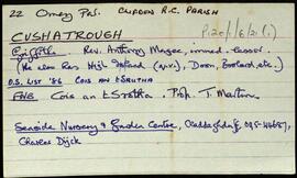
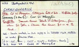
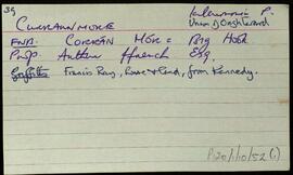
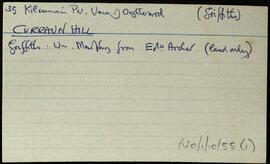
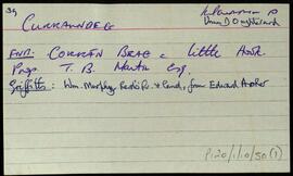
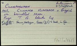
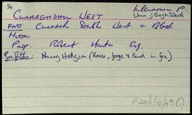
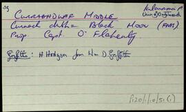
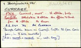
Set of index cards describing the physical features of Cushatrower [Cois Treabhair], for the most part a series of lakes and hills. Included in the descriptions are Croc an 'ow', Cara Móra, Crocán na Scraith, Seanbhantraí, Loch Scailp, Loch Chait, The White Lakes, and Loch Caimín. Paddy and Francie Linnane are credited as the sources of some of the information given.
Robinson,Tim,Linnane,Paddy,FrancieIndex
655 Archival description results for Index
Set of index cards giving a description of the townland of Cushatrough, [Cois an tSrutha]. Included are descriptions of a mass rock, located in the front garden of a Mrs. Gough's house, Dún Bhigeáin, and an oyster farm. Local people Peter and Ann Molloy, and Tom and Philomena Welsh are credited with providing some of the local information.
Robinson,Tim,Molloy,Peter,Ann,Welsh,Tom,PhilomenaSet of index cards describing some of the local features of the townland of Currywongaun, [Corr Uí Mhongáin]. Included are descriptions of Cnocán Mór, Thornton's Hill, Fearsaí, The Plantation, and Marconi Station (three masts which lie on Currywongaun Hill).
Robinson,TimIndex card relating to the townland of Curraunmore, [An Corrán Mór] part of the Union of Oughterard.
Robinson,TimIndex card relating to the townland of Curraun Hill, [Cnoc an Chorráin].
Robinson,TimIndex cards relating to the townland of Curraun Beg, [An Corrán Beag].
Robinson,TimIndex card relating to the townland of Currarevagh, [An Currach Riabhach].
Robinson,TimIndex cards relating to the townland of Curraghduff West, [An Currach Dubh Thiar]. A note giving some information from the Field Name Books Small Names Index.
Robinson,TimIndex cards relating to the townland of Curraghduff Middle, [An Currach Dubh Láir], part of the Union of Oughterard. Some notes from the Field Name Books Small Names Index.
Robinson,TimSet of index cards describing some of the local features of the townland of Curragh [An Currach]. Included are descriptions of Carraig na gCapall, Soul Island, Carraig na bPortán, Inishbroon, Renvyle Point, Bearna Bhuí, Carraig Ghéar, Carraig an Choismeig, An Fó Mhór, Fó Toby, Fóin Fada, Carraig an Ealtóg, Carraig Ramhar, Carraig Ard, Bearna na Gaoithe, Lochán Mór, Aill Mhór, Carraigíní, Carraig an Róist, Fó Mhurchí, Cuainín Bán, Cnocán na Ceilpe, Duirling ó Dheas, Cuainín Labhrais, Leac an tSleabhcáin, Carraig na nGasúr (used to be known as Carraig an Fhómhair, but was renamed after the drowning of six young boys fishing for pollack), An Leac Buí, Idir Dhá Mhaoil, Fó na Fola, Duirling ó Thuaidh, Maol Mór and Maol Beag, Cuanín an tSimléir, Three rocks (named An Lao, An Bhó, and An Tarbh), An Fóin, Carraig an Altóir, Aic an Altóir, Carraig an Bhallaigh Mhóir, An Fóin Fada, Taobh ó Thuaidh, Carraig Uí Garéadáin, Fó Glais, Fó na Rísigh, Béal Gearr, Cathair an Dúin, Cnoc na Síog, The Blake's Farm, and Stáid. Some of the information gathered for this placename was derived from Paddy Heanue of Letterbeg, the CW map, and Paddy Fitzpatrick.
Robinson,Tim,Heanue,Paddy,Fitzpatrick