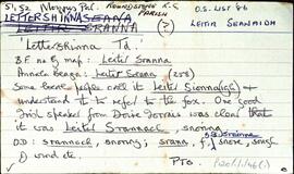
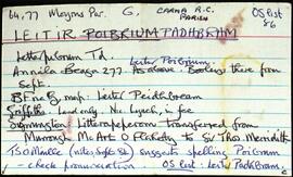
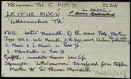
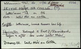
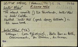
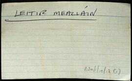
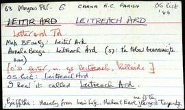
Index

Elements area

Taxonomy

Code

Scope note(s)

    Source note(s)

      Display note(s)

        Hierarchical terms

        Index

          Equivalent terms

          Index

            Associated terms

            Index

              655 Archival description results for Index

              655 results directly related Exclude narrower terms
              Attigoddaun
              UGA P/P120/1/6/4/1 · Item
              Part of Personal

              Set of index cards describing some of the local features of the townland of Attigoddaun, [Áit Tí Geadáin]. A note about (Tomáis) de Bhaldraithe about placenames that begin with Áit Tí, that a personal name usually follows. A note about a local stabdubg stone, and a credit to Mike Gibbons.

              Untitled
              Aughrus Beg
              UGA P/P120/1/6/5/1 · Item
              Part of Personal

              Set of index cards describing some of the local features of the townland of Aughrus Beg, [Eachros Beag]. Included are descriptions of Oileán Chaorach, Foiriúnach Thiar, Codú (Cuddoo Rock), Caoile Mhór, Loch an tSáile, Gazebo (a hill), Poll Tolladh/Poll Tulach, and a brief note on the Coneys who leased the area. Local man Conor Laffy is credited with providing some of the information.

              Untitled
              Aughrus More
              UGA P/P120/1/6/6/1 · Item
              Part of Personal

              Set of index cards describing some of the local features of the townland of Aughrus More, [Eachros Mór]. Included is a brief description of a megalithic structure.

              Untitled
              UGA P/P120/1/6/7/1 · Item
              Part of Personal

              Set of index cards describing some of the local features of the townland of Ballymaconry/Kingstown Glebe, [Baile Conraoi]. Included are descriptions of Kingstown Bay, Ballymaconry School, Tobar Muire, and Glebe House (used as an orphanage, and burned in the early 1920's).

              Untitled
              Barnahallia
              UGA P/P120/1/6/8/1 · Item
              Part of Personal

              Set of index cards describing some of the local features of the townland of Barnahallia, [Bearna Aille]. A note summarising information from Griffith's Valuation, the OS map, the Field Name Book, and the Martin Estate Sale of 1849.

              Untitled
              Belleek
              UGA P/P120/1/6/9/1 · Item
              Part of Personal

              Set of index cards describing some of the local features of the townland of Belleek, [Béal Leice]. Included are a note on the name, which can be explained by the natural bridge marked on the OS map. A note on Caladh Beag, Sloper cliffs, megalith, the Seanbhalla, Fó Chait, and Fó na bhFreangach. Rory Lavelle and James Conneelly, both of Clifden are credited with provding some of the local information.

              Untitled
              Boolard
              UGA P/P120/1/6/10/1 · Item
              Part of Personal

              Set of index cards describing some of the local features of the townland of Boolard, [An Bhuaile Ard]. Included are descriptions of The Priory (the big house on the south of the road opposite Boolard Island, sometimes known as The Bishop's House), The Bishop's Rock, Copper Mine (marked as shaft on the OS), Boolard Island, and a note on Reverend Anthony Magee who was a significant land owner in the area in the 19th century. Patrick Joyce of Coolacloy is credited with providing some of the local information.

              Untitled
              Claddaghduff
              UGA P/P120/1/6/11/1 · Item
              Part of Personal

              Set of index cards describing some of the local features of the townland of Claddaghduff, [An Cladach Dubh]. Included are a description and a brief history of the Roman Catholic chapel, thought to havebeen build c. 1845. A note too on an area of large fields known locally as Acres, to the west of the chapel.

              Untitled
              Clifden Demesne
              UGA P/P120/1/6/12/1 · Item
              Part of Personal

              Set of index cards describing some of the local features of the townland of Clifden Demesne, [Diméin an Chlocháin]. Included are descriptions of Dumhach Beag Quay, Caster Grounds, Clifden Castle, a note on the D'arcy's, Eyre's Graveyard, The Cove (also known sometimes as the ladies beach), The Mine Road, Standing Stones, and a brief note on the Eyres.

              Untitled
              Clifden
              UGA P/P120/1/6/13/1 · Item
              Part of Personal

              Set of index cards describing some of the local features of the townland of Clifden, [An Clochán]. Included are descriptions of Clifden Workhouse, Clifden Harbour, Methodist Chapel, Clifden District Hospital, the Former Church of Ireland School, the Parochial School, Moran's Lake, Quay House, the Showground, Cumann Lucht Capaillíní Chonamara, Millar's Connemara Tweeds Ltd, Clifden Racecourse, Fahy's Field in Dooneen, Bráideóg, Clifden Mill, Abhainn Glinn, Beach Road, Fr. Miley's Den, the Coach Works which belonged to the Eyre family, Croc na h'Eiglea, Cailleach na Luibhe, a note on the Black and Tans, a note on the Clifden missions, the Courthouse, Whelan Monument, the Convent of Mercy, Glenown Orphanage, Salt Lake Manor, Clifden Bay Hotel and a note on various other hotels in the area, and St. Joseph's Convent. Various sources are credited as providing information, including Rory Lavelle, T. Joyce, K. Villiers, a manuscript in Clifden Library, and Sr. Bernard of Clifden Hospital.

              Untitled