Click on the image to access the full item on the digital library
Identity area
Reference code
Title
Date(s)
Level of description
Extent and medium
22pp
Context area
Name of creator
Biographical history
Repository
Archival history
Immediate source of acquisition or transfer
Content and structure area
Scope and content
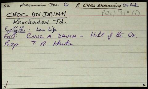
Set of index cards describing some of the local features of Cnoc an Daimh, [Knockadav]. Robinson offers a translation of Hill of the Ox, derived from the Ordnance Survey Field Name Books. Included are descriptions of Loch na hEasléime, Tmnach Lug na gCléireach, the Old Road to Derrough North, Tobar Beannaithe, Cara Throiscín, An Leacht/Leachta Labhráis, An Tall Darach, a note on the Salmon Hatchery (one of the earliest in Ireland), Loch Bhallaí Mhongáin, Loichín Nora Ní Niaidh, Seana Mhac Conraoí, Loichín Bharr an Éadain, Loch an Fhraoigh, Aill an Chliabhraigh, Barr na dTamhnachaí Bána, Criogán na Seithe, An Draem Bhoiste, Binn Ard Loch an Daimh, Log na gCleireach, and Garraí Ruaidí. Paddy Folan of Scríb, and Paddy Joyce of Úraid are credited as being local sources of information.
Appraisal, destruction and scheduling
Accruals
System of arrangement
Conditions of access and use area
Conditions governing access
Conditions governing reproduction
Language of material
English
Script of material
Language and script notes
Physical characteristics and technical requirements
Finding aids
Allied materials area
Existence and location of originals
Existence and location of copies
Related units of description
Alternative identifier(s)
Access points
Subject access points
- Loch na hEasléime
- Tmnach Lug na gClireach
- Tobar Beannaithe
- Cara Throiscín
- An Tall Darach
- Salmon Hatchery
- Loch Bhallaí Mhongáin
- Loichín Nora Ní Niaidh
- Seana Mhac Conraoí
- Loichín Bharr an Éadain
- Loch an Fhraoigh
- Aill an Chliabhraigh
- Barr na dTamhnachaí Bána
- Criogán na Seithe
- An Draem Bhoiste
- Binn Ard Loch an Daimh
- Log na gCleireach
- Garraí Ruaidí
- Knockadav (Galway
- Ireland : Townland)