Identity area
Reference code
Title
Date(s)
Level of description
Extent and medium
14pp
Context area
Repository
Archival history
Immediate source of acquisition or transfer
Content and structure area
Scope and content
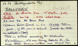
Set of index cards describing some of the local features of the townland of Ballynew [An Baile Nua]. Descriptions are given of a 'pair of standing stones', Fuaigh an Sconsa (Ooeyasconsa on the OS maps, and known locally as Fo na Sconsaí), Fó na Bróinge (Tim Robinson believes the cove may be named for its boot-like shape), Fó na Labhráis (Ooeylaunlauraush on the OS maps), Fó na Bhistí, Fuaigh an Duine Mhairbe (Ooeywaria on the OS maps), Binn Ghlais, Fó an Uisce, Fó an Bhradáin, Megalithic tombs close to the Children's Burial Ground, Lios (the site of the former Mission School), and the Shrine, which marks the traditional site of St. Ceannan's beheading. J O'Toole of Moyard, Mr. Heanue of Bundouglas, and Con Mullen of Ballynew are credited with providing some of the information.
Appraisal, destruction and scheduling
Breisiúcháin
System of arrangement
Conditions of access and use area
Conditions governing access
Open
Coinníollacha a rialaíonn atáirgeadh
Teanga an ábhair
Script of material
Nótaí teanga agus scripte
Physical characteristics and technical requirements
Áiseanna aimsithe
Allied materials area
Existence and location of originals
Existence and location of copies
Related units of description
Note
[Table]
Catalog
Alternative identifier(s)
Access points
Subject access points
Place access points
Name access points
Genre access points
Description identifier
Institution identifier
Rules and/or conventions used
Status
Level of detail
Dátaí cruthaithe athbhreithnithe nó scrios
11/08/2014
26/05/2015