Identity area
Reference code
UGA P/P120/1/2/33
Title
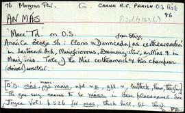
An Más
Date(s)
Level of description
Item
Extent and medium
11pp
Context area
Repository
Archival history
Immediate source of acquisition or transfer
Content and structure area
Scope and content
Set of index cards describing the local features of the townland of An Más [Mace]. Features described include Carrig A Mungan, Béal an Mhása An Murlach, Céibh an Mhása (a pier shown on the OS maps), Loch an Phúca, Crompán na gCapall, An Fhuaigh, Na Roisíní, An Damba, and Barr an Mhulaigh. As well as Nimmo's 19th century map and un-named local sources of information, Seán McDonncha is credited with providing some of the local information.
Appraisal, destruction and scheduling
Breisiúcháin
System of arrangement
Conditions of access and use area
Conditions governing access
Open
Coinníollacha a rialaíonn atáirgeadh
Teanga an ábhair
Script of material
Nótaí teanga agus scripte
Physical characteristics and technical requirements
Áiseanna aimsithe
Allied materials area
Existence and location of originals
Existence and location of copies
Related units of description
Note
[Table]
Catalog
Alternative identifier(s)
Access points
Subject access points
Place access points
Name access points
Genre access points
Description identifier
Institution identifier
Rules and/or conventions used
Status
Catalogued
Level of detail
Dátaí cruthaithe athbhreithnithe nó scrios
01/08/2014
18/11/2019