Identity area
Reference code
Title
Date(s)
Level of description
Extent and medium
11pp
Context area
Repository
Archival history
Immediate source of acquisition or transfer
Content and structure area
Scope and content
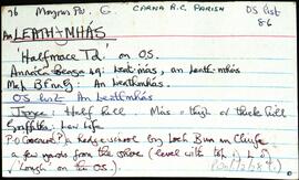
Set of index cards describing the local features of the townland of An Leathmhás [Halfmace]. A note on a hedge school a few yards from the shore, and a description given of Tobar Carraig an Mhaistire, the Mace Head Atmospheric Research Centre, Cuainín na Bothóige (an account of a tragic incident that took place in its history), Oileán an Bhromaigh (Colt Island on the OS maps), Duirling na Spáinneach (where an Armada ship wrecked), Ceann Mása (Mace Head), An Dhitheallach, Campainn, Liath Brás (referred to as Lebros Rock on the 19th century maps), and Cuan an Leath Mhás. UCG lecturers Dr. Gerard Jennings, Dr. T C O'Connor, and Dr. A. F. Roddy, who are associated with the Mace Head Atmospheric Research Centre provided some of the information, and T. P. Kilfeather's Book 'Ireland, Graveyard of the Spanish Armada' is also a quoted source of information for this townland.
Appraisal, destruction and scheduling
Breisiúcháin
System of arrangement
Conditions of access and use area
Conditions governing access
Open
Coinníollacha a rialaíonn atáirgeadh
Teanga an ábhair
Script of material
Nótaí teanga agus scripte
Physical characteristics and technical requirements
Áiseanna aimsithe
Allied materials area
Existence and location of originals
Existence and location of copies
Related units of description
Note
[Table]
Catalog
Alternative identifier(s)
Access points
Subject access points
Place access points
Name access points
Genre access points
Description identifier
Institution identifier
Rules and/or conventions used
Status
Level of detail
Dátaí cruthaithe athbhreithnithe nó scrios
31/07/2014
28/05/2017