Click on the image to access the full item on the digital library
Identity area
Reference code
Title
Date(s)
Level of description
Extent and medium
11pp
Context area
Name of creator
Biographical history
Repository
Archival history
Immediate source of acquisition or transfer
Content and structure area
Scope and content
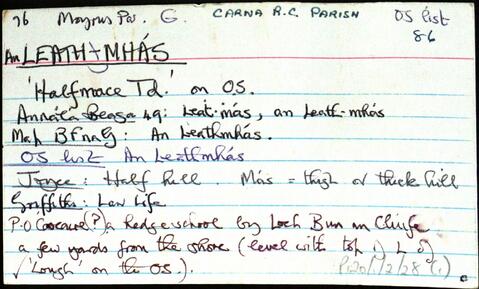
Set of index cards describing the local features of the townland of An Leathmhás [Halfmace]. A note on a hedge school a few yards from the shore, and a description given of Tobar Carraig an Mhaistire, the Mace Head Atmospheric Research Centre, Cuainín na Bothóige (an account of a tragic incident that took place in its history), Oileán an Bhromaigh (Colt Island on the OS maps), Duirling na Spáinneach (where an Armada ship wrecked), Ceann Mása (Mace Head), An Dhitheallach, Campainn, Liath Brás (referred to as Lebros Rock on the 19th century maps), and Cuan an Leath Mhás. UCG lecturers Dr. Gerard Jennings, Dr. T C O'Connor, and Dr. A. F. Roddy, who are associated with the Mace Head Atmospheric Research Centre provided some of the information, and T. P. Kilfeather's Book 'Ireland, Graveyard of the Spanish Armade' is also a quoted source of information for this townland.
Appraisal, destruction and scheduling
Breisiúcháin
System of arrangement
Conditions of access and use area
Conditions governing access
Coinníollacha a rialaíonn atáirgeadh
Teanga an ábhair
Béarla