Identity area
Reference code
UGA P/P120/1/8/5
Title
An Cheathrú Gharbh
Date(s)
Level of description
Item
Extent and medium
6pp
Context area
Repository
Archival history
Immediate source of acquisition or transfer
Content and structure area
Scope and content
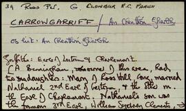
A set of index cards outlining some of the local features of the townland of An Cheathrú Gharbh, [Carrowgarriff]. Summary information from Griffith's Valuation, a note on the copper and lead mine used up until approximately the 1910's until it flooded out, a note on the Clement family who ran the lead mine during the 19th century, and a detailed note on Caisleán na Circe from the 13th century.
Appraisal, destruction and scheduling
Breisiúcháin
System of arrangement
Conditions of access and use area
Conditions governing access
Open
Coinníollacha a rialaíonn atáirgeadh
Teanga an ábhair
Script of material
Nótaí teanga agus scripte
Physical characteristics and technical requirements
Áiseanna aimsithe
Allied materials area
Existence and location of originals
Existence and location of copies
Related units of description
Note
[Table]
Catalog
Alternative identifier(s)
Access points
Subject access points
Place access points
Name access points
Genre access points
Description identifier
Institution identifier
Rules and/or conventions used
Status
Catalogued
Level of detail
Dátaí cruthaithe athbhreithnithe nó scrios
24/10/2014
02/06/2015